


- A M7.0 earthquake struck beneath the island of Luzon, Philippines early Wednesday July 27, 2022
- The major earthquake struck early Wednesday morning in Abra Province in northwestern Luzon at 8:43 AM local time (00:43 UTC) at a very shallow depth of 10.0 km. The earthquake was the result of oblique reverse faulting as the Sunda Plate subducted eastward. The tectonic setting beneath this portion of the Philippines is highly complex with several notable historical earthquakes. On July 16, 1997, a M7.7 earthquake erupted in central Luzon (closer to Manila), causing approximately 1,600 fatalities.[1]
- Luzon is the most populous island in the Philippines, with the country capital Manila to the south. Manila is home to approximately 1.78 million people (as of 2015) and is located just over 200 miles from the earthquake epicenter. Light ground shaking was felt in the capital.
- Areas in the northwestern portion of the island were subjected to the most extreme ground shaking (Figure 1). The United States Geological Survey (USGS) estimates that 6.4 million people felt moderate to severe ground shaking, with another 7.6 million experiencing light ground shaking.
Figure 1: Modified Mercalli Intensity map of Luzon, Philippines from the July 27 M7.0 earthquake.
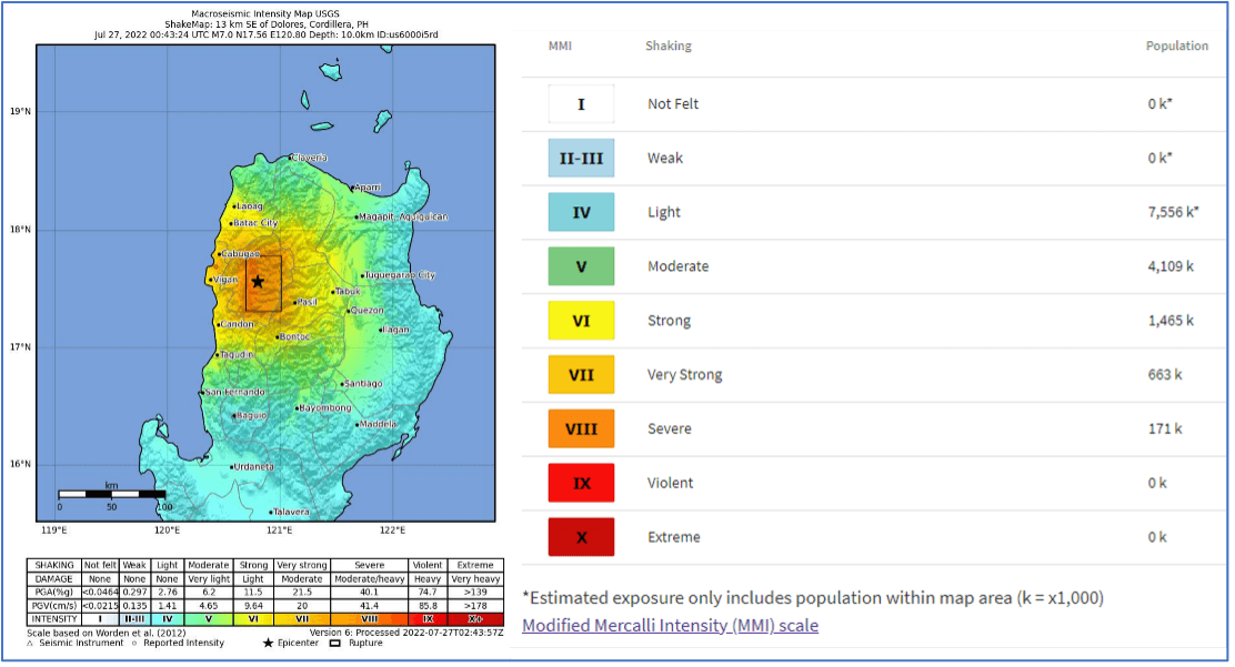
Source: USGS 2022.
© 2022 CoreLogic,Inc., All rights reserved.
- Initial reports from the Philippines indicate fatalities and building damage
- Early local reports have indicated that there have been at least four fatalities, 60 injured and 173 buildings damaged. The majority of the injuries were in Abra.[2]
- On the coast in Vigan, stones fell from The Bantay Church Bell Tower, a relic from the Spanish colonialization period.
- The Philippines lies in a tectonically active region of the globe and building codes and construction practices reflect the elevated risk. Residential and commercial structures in more remote areas of the Philippines are primarily constructed of masonry and adobe materials. In more urban environments, reinforced concrete materials are utilized at a greater percentage relative to adobe.
- The first building codes were established in the Philippines in 1970’s when the 1977-PD 1096 National Building Codes were put in place. The codes were updated in the mid-2000’s and again in 2010. Older constructions that were built to lesser codes or when building codes were nonexistent will be significantly more vulnerable to ground shaking.
- Secondary earthquake hazard risk is high in this region of the Philippines
- Secondary perils associated with ground shaking, such as landslides and liquefaction, can generate substantial damage in addition to shaking. Liquefaction is process where water-logged sediment loses its strength in response to ground shaking. When it occurs beneath buildings, severe damage can occur.
- Abra and the surrounding provinces in northern Luzon are quite mountainous. The region is susceptible to landslide risk. As of this morning, 58 landslides have been triggered and reported by the M7.0 earthquake, resulting in numerous major road closures. 2
- Secondary earthquake hazards can sometimes generate greater damage than initial ground shaking.
[1] United States Geological Survey (USGS), 2022. https://earthquake.usgs.gov/earthquakes/eventpage/us6000i5rd/executive. Accessed July 27 2022.
[2] Morales, Neil and Lema, Karen, Powerful 7.1 earthquake strikes Philippines; at least 4 dead. (Reuters 2022). https://www.reuters.com/world/asia-pacific/magnitude-72-earthquake-strikes-luzon-philippines-emsc-2022-07-27/. Accessed July 27 2022.
© 2022 CoreLogic,Inc., All rights reserved.


