


- A flash flood warning is in place for millions residing in Dallas-Fort Worth due to severe weather and heavy rainfall.
- Heavy rainfall from a stalled frontal boundary over Central Texas inundated the Dallas-Fort Worth (DFW) metro area starting on Sunday, August 21. Rain, often very heavy, continued to fall throughout Monday, August 22. The storm system is responsible flood watches and warnings across the southern U.S. from Arizona to Louisiana.
- The Dallas-Fort Worth International Airport recorded 9.19 inches of rain over a 24-hour period ending at 2:00 p.m. local time on Monday afternoon. According to the National Weather Service (NWS), Sunday and Monday’s 24-hour rainfall total at DFW International ranks second in terms of 1-day precipitation depth totals for this area in recorded history.[1]
- Rainfall totals recorded from Sunday through Monday were greater than the July, August and September three-month combined historical average (6.98 inches). This August now ranks as the wettest August in recorded history for Central Texas.1
- Flooded roadways and homes Dallas-Fort Worth are the most significant hazards to residents.
- All of North and Central Texas was under a flood watch at some point between Sunday, August 21 and Monday, August 22. Areas alongside and north of the I-20 corridor were under flash flood warnings from Sunday night through Monday afternoon. A flash flood warning indicates rapidly-rising, swift-moving water which can sweep vehicles off roadways and/or inundate first floors and basements of buildings.
- As of Monday morning, the Dallas City Flooded Roadway System indicated that 44 streets in the city are flooded.[2] Rapidly-rising flash flood waters inundated I-30 in Dallas overnight trapping vehicles. The Dallas Fire Department reported that more than 10 water rescues were conducted Sunday night.
- The full extent of flash and/or riverine flooding in the Dallas-Fort Worth area will not be determined until recovery crews can assess the situation. Local photographs of flooded apartments, submerged vehicles, inundated interstates and vehicles being swept along roads have been reported. A state of disaster was declared in Dallas County based on preliminary damage survey results.
- High concentrations of high-value homes at risk for flash floods
- The Federal Emergency Management Agency (FEMA) Special Flood Hazard Areas (SFHAs) designate regions with high flood risk (i.e., 1% or 0.2% annual probability of flooding). The FEMA flood zone maps are used to determine areas in which homeowners are required to purchase flood insurance. The SFHA risk is determined via detailed hydraulic modeling of large to moderate bodies of water, but it can be difficult to capture the risk around small streams, creeks or urban aqueduct systems. Additionally, the hazards associated with pluvial-based, urban flooding (e.g., flash flooding) are not easily captured in the SFHA maps.
- Flash flood risk extends beyond the floodplains designated by FEMA, as was seen in the greater St. Louis area in early August. In Dallas County, single-family residences (SFRs) in the SFHA are generally concentrated along the Trinity River which runs through downtown Dallas. Figure 1 (Top image) shows the Dallas County ZIP Codes with the highest proportion of SFRs in the SFHA (darker reds) relative to the total number of SFRs in mapped regions. However, when you consider flash flood in addition to riverine flood risk, then the total flood risk extends far beyond the floodplains of the Trinity River and its tributaries. Figure 1 (Bottom image) depicts the ZIP Codes with the highest proportion of SFRs that are at Extreme, Very High or High Flash Flood Risk, according to CoreLogic’s Flash Flood Risk Score. Nearly two-thirds of Dallas ZIP Codes, especially those north of downtown, have a high number of SFRs at an elevated risk to flash flood.
Figure 1
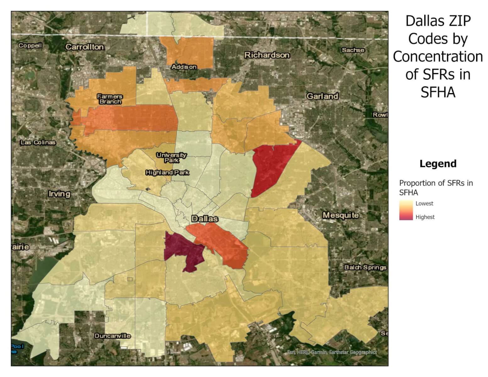
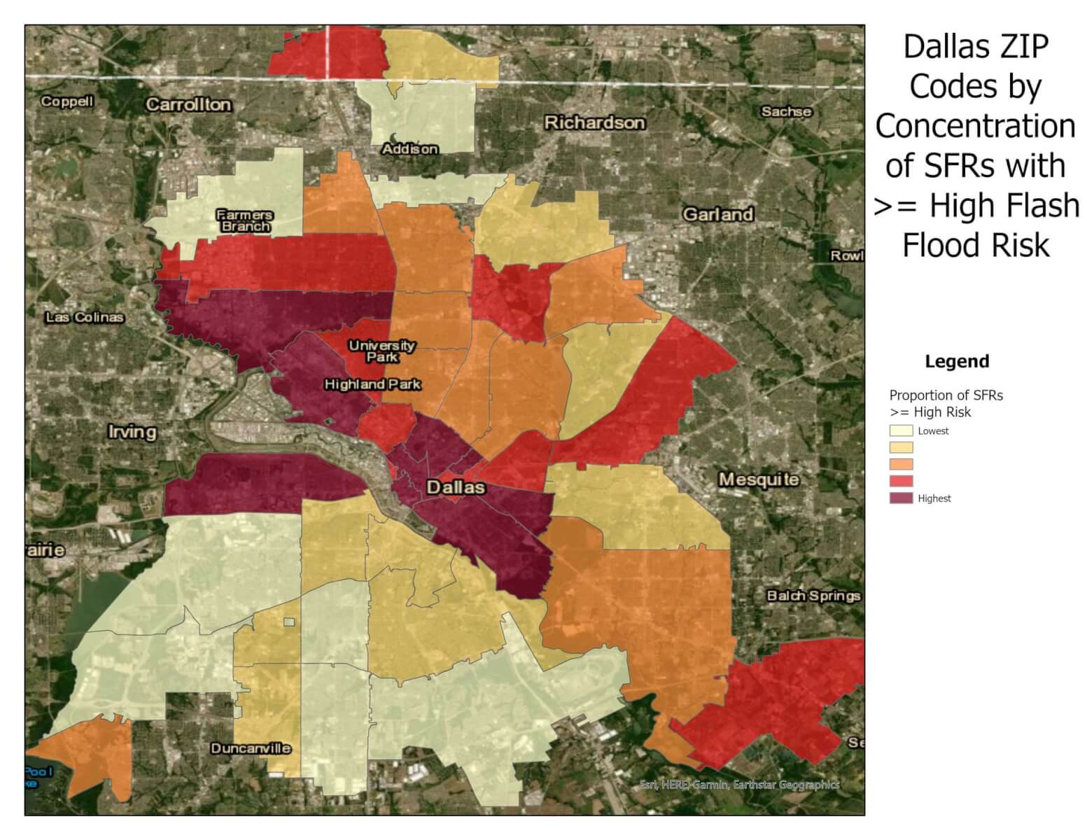
Source: CoreLogic 2022
© 2022 CoreLogic,Inc., All rights reserved.
- The areas of Dallas located north of the Trinity River with higher concentration of SFRs in the SFHA, such as Farmers Branch, or with elevated flash flood risk, such as University Park, tend to be homes with the highest reconstruction value (RCV). Figure 2 shows the Dallas ZIP Codes by average RCV per SFR in either the SFHA (top image) or with elevated flash flood risk (bottom image).
Figure 2
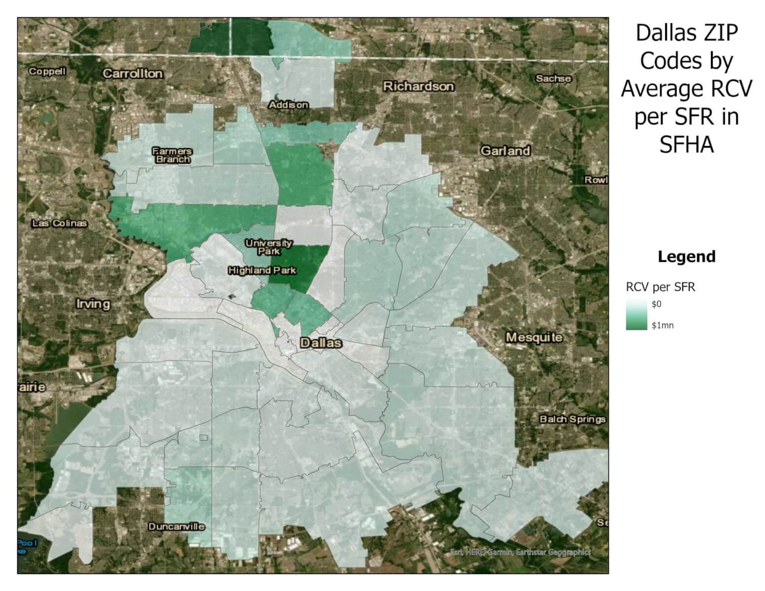
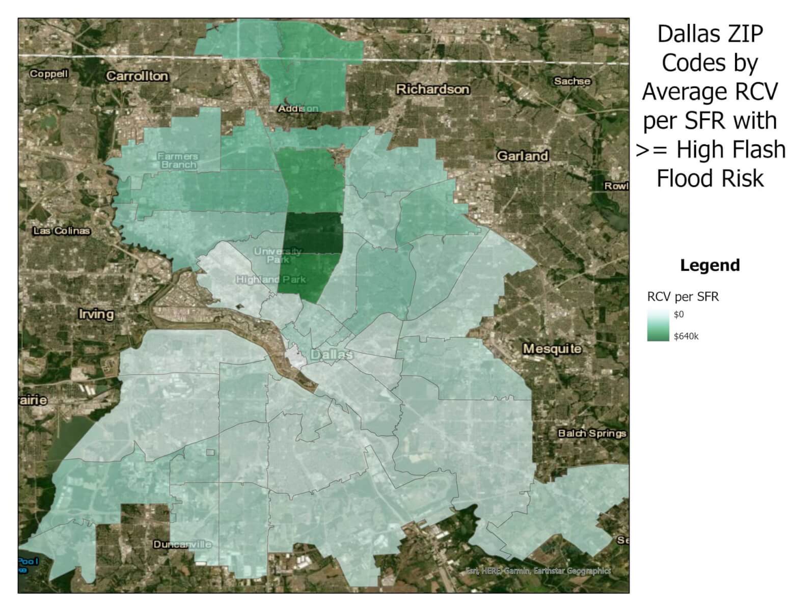
Source: CoreLogic 2022
© 2022 CoreLogic,Inc., All rights reserved.
- Areas with greater concentrations of high-value homes with an elevated risk of riverine or flash flood can be problematic. A significant rainfall event where the risk of flash flood damage is high, such as the one that inundated the DFW metro area this weekend, has the potential to generate material flood losses.
CoreLogic is continuing to monitor the situation in the DFW area. Updates will be posted to www.hazardhq.com.
© 2022 CoreLogic,Inc., All rights reserved.
[1] National Weather Service – Fort Worth, 2022.
[2] City of Dallas Flooded Roadway Warning System, Flooded Roadway Warning System Current Closures. (City of Dallas FRWS, 2022). http://www.ci.dallas.tx.us/sts/html/frws.html. Accessed August 22, 2022.


